Smart Digitization identifies database knowledge gaps that bottleneck analysis and reporting, then ensures that the right technologies generate the right digital information for your output needs.
We apply drones, computing, and AI to assess and cleanse tower databases, generate critical intelligence, and inform teams with a new digital core.


Delivering Answers.
Not software.
Advances in drones, 3d modeling, data processing, digital twins, and AI make it possible for many tower services to be conducted remotely or automatically. Visual Intelligence helps companies take advantage of these emerging trends by providing services to digitize sites and generate stamped drawings, reports and analysis – providing the same deliverables you receive from traditional managed service companies, as well as a completely digitized database to accelerate future use cases.
Us |
Others |
||
Informed Digitization PlanningWe conduct a pre-digitization assessment to form the basis for a smarter, site-specific collection plan. |
Nonspecific Regional CollectionsSite status is uncertain and data is collected without knowledge of the underlying site-level information. |
||
Full Data Spectrum & FootprintWe collection tower and ground data across a range of Inspection and Engineering Class 3D data. |
Limited Quality & Partial CoverageOperators utilize Inspection Class off-the-shelf drones, and are not qualified to use ground-based sensors. |
||
Turnkey Managed ServicesWe generate engineering-stamped drawings, reports, and analysis using the site 3D model and digital twin. |
DIY with Out-of-the-Box SoftwareSoftware providers provide self-generating analysis tools that solve for partial requirements and have low reliability. |
||
Digital-First ApproachWe use digital and AI-based methods to deliver traditional services more quickly and inexpensively. |
Manual WorkflowsTraditional managed service companies rely on costly site visits and labor-intensive report generation. |
||
Assess and review your database to identify gaps and opportunities.
Database reviews are based on a criterion you set and tailored around your specific use case and objectives.
Assessments identify existing documentation requirements, as well as recommendations for optimizing tower utilization.
Pre-collection assessments form the basis for a smarter, fact-based digitization plan for aerial and ground-based collection.

Cleanse and refresh your database by digitizing sites and using AI.
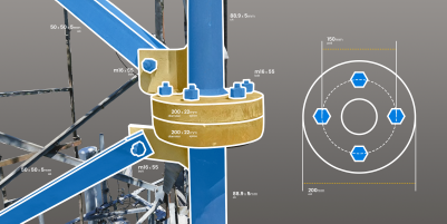
Tower structures and ground assets are digitized according to the assessment results and information requirements.
We digitize sites across the full spectrum of drone data, depending on the need, and collect both aerial and ground-based datasets.
Using the 3D data, we apply AI-based automation to refresh existing site information and tower analytics.

Generate stamped site drawings, reports, or analysis.
We provide turnkey managed services on top of digital twinning to rapidly produce site drawings, reports and analysis.
All managed services utilize 3D modeling and AI-tools to accelerate tower analysis and reduce the cost of services.
When required, we can also provide Engineering reviews and stamped reporting based on the site digital replica.

Inform your team with a new, centralized digital source of truth.
Log into a web-based dashboard with portfolio-wide analysis tools and site-level details and documentation.
Establish a location-intelligent GIS database, and access your as-built site digital twins for internal review and future lifecycle uses.
Integrate with your existing databases with feed up-to-date site information and analysis into the tools you use most.