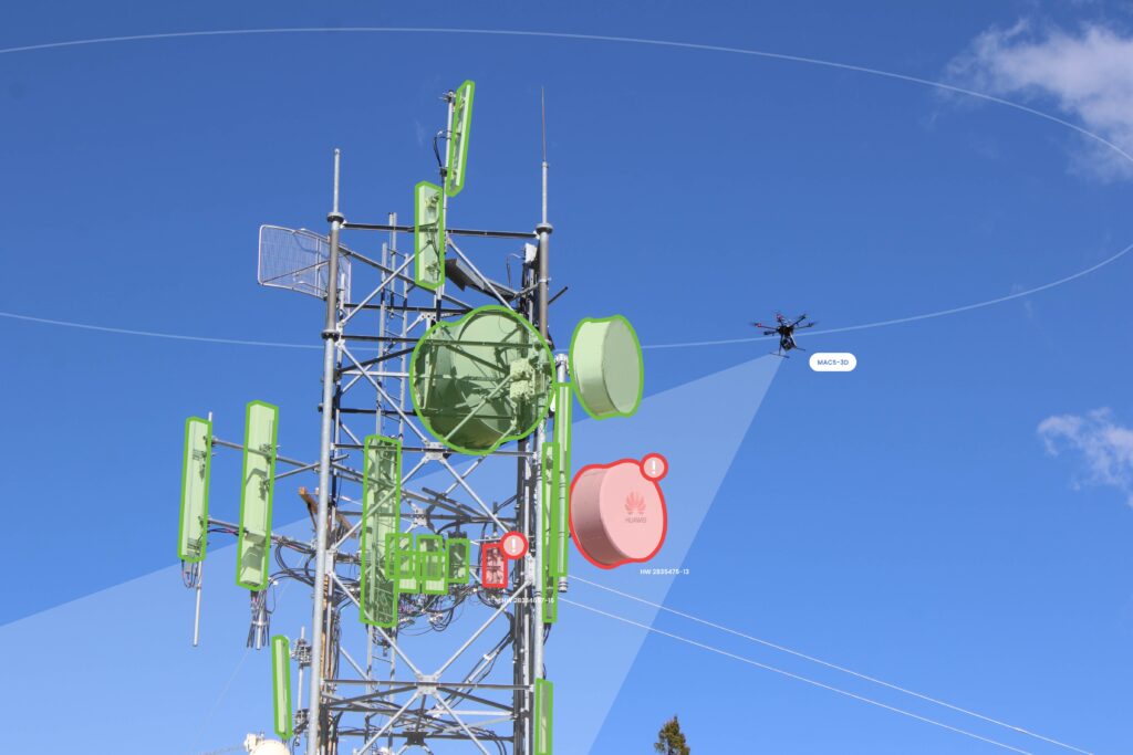
Visual Intelligence, the first unified drone platform to digitize physical infrastructure with millimeter accuracy, partners with Bentley Systems…
NEWS
Visual Intelligence and Red Mountain Scientific Partner to Offer Full-Spectrum Data Services to Support Ongoing “Rip & Replace” Activities
VISUAL INTELLIGENCE AND RED MOUNTAIN SCIENTIFIC PARTNER TO OFFER FULL-SPECTRUM DATA SERVICES TO SUPPORT ONGOING “RIP & REPLACE” ACTIVITIES
Published by
Visual Intelligence
Press Team
Houston, TX – May 10, 2022 – Visual Intelligence and Red Mountain Scientific (RMS) announce a partnership to provide rural carriers with a unified solution that encompasses a full spectrum of data and analytical services to support “Rip & Replace” activities. Visual Intelligence, the first unified drone platform to digitize tower infrastructure with millimeter accuracy, will work with RMS, a comprehensive image intelligence platform for wireless infrastructure management, to digitize sites that possess untrusted network gear and simulate changes required to replace equipment.
With a patented drone sensor that collects data that is 10-20 times more accurate than mobile Lidar technologies and 50-100 times more accurate than single camera commercial drones, Visual Intelligence generates a new class of engineering-grade drone data to produce millimeter-accurate tower 3d models that serve as a foundation for engineering analysis, streamlining pre- and post-modification workflows.

RMS provides a fast, lightweight, and easy-to-use software that enable rural telecom providers, engineering firms, and local industry to leverage the most advanced image data acquisition and analysis techniques available for the management of their broadband facilities and wireless tower infrastructure.
Together, the collaboration of Visual Intelligence and Red Mountain Scientific provides rural carriers with a complete solution for monitoring and managing “Rip & Replace” activities. Engineering Class 3D models aide Digital Twin analysis, helping carriers simulate equipment swaps and understand available capacity when legacy data is incomplete or inaccurate. In concert with the RMS platform, carriers will have one central repository for all tower imagery, including data from smartphones and drones, to streamline antennae inventory, identify structural issues, locate available space for additional equipment, and visually document site walks and closeouts.
“Over the tower lifecycle, carriers require different classes of data to carry out routine activities. When there has been a structural change, engineering-grade 3d data is needed to create an as-built reality model and generate an up-to-date design model. Other times, for work verification or conditional assessment, inspection class data from an iPhone or off-the-shelf drone will suffice,” said Ted Miller, Founder and Chairman of Visual Intelligence. “Together with RMS, we now offer carriers a unified source of tower truth that incorporates the full spectrum of 2d and 3d data, providing value that is useful long after Rip and Replace is complete.”
“Integrating Visual Intelligence 3d data and Digital Twin technology into the RMS platform will provide carriers with a complete solution for managing pre and post-modification Rip and Replace activities,” said Mike Moses, CEO and Founder of RMS. “For rural carriers who face service downtime, high costs and labor shortages, our unified solution automates both inspection and engineering activities, accelerating workflows and reducing the labor required.”
Both Visual Intelligence and Red Mountain Scientific are currently servicing Rip & Replace customer projects.
ABOUT VISUAL INTELLIGENCE
Visual Intelligence is a unified drone sensor and software automation platform that digitizes physical infrastructure with millimeter accuracy to reliably deliver 3D, engineering-grade asset intelligence.
Using patented dual-sensor drone technology and proprietary enterprise software, Visual Intelligence generates billions of datapoints to map exponentially more measurable surface area than any alternative aerial or ground-based method. Our unique sensor-software pairing is the first industry solution that enables enterprises to capture and execute around engineering-grade digital twins. By maximizing data fidelity and coverage, we’re exponentially increasing the ability of artificial intelligence to automate performance capacity at an engineering level, feeding insights upstream and across new business units, vendors and geography.
www.vitowers.com
ABOUT RED MOUNTAIN SCIENTIFIC
Red Mountain Scientific (RMS) provides automated data collection, web-based asset management, and machine learning software for companies in the fast-growing wireless sector. The solution integrates field-acquired image data with tower and network asset identification via our enterprise-grade cloud platform, to provide an intuitive visual interface for the management of these facilities. The streamlining of damage detection, asset inventory collection, and vacancy assessment results in a higher level of operational insight, time/cost savings, improved employee safety, and enhanced revenue generation.
www.redmtnsci.com

