The drone industry has spent years making incremental improvements to the ways tower companies operate – gradually fine-tuning technology…
ARTICLE
Solving the tower industry ‘drone data gap’ with millimeters
SOLVING THE TOWER INDUSTRY ‘DRONE DATA GAP’ WITH MILLIMETERS

Written by
Josh Meler
Chief Marketing Officer
The drone industry has spent years making incremental improvements to the ways tower companies operate – gradually fine-tuning technology whose capabilities are inherently limited by the data that drone sensors can produce.
Drone companies have spent years crafting tower solutions around the intrinsic limitations of low fidelity drone sensors, often using hobbyist drones. To account for poor zoom and low-resolution cameras, drones spend hours flying complex missions dangerously close to towers. To address field of view issues and orbit drift that creates gaps in point cloud data, drone pilots must frequently revisit sites to retry captures. To generate realistic-looking 3D models, AI has been trained to estimate missing structures.
While off-the-shelf drone solutions provide high-level visibility into tower inventory, they fail to answer enough questions to save a truck roll.
Every industry has a minimum accuracy that must be achieved before digital twins can provide enterprise-wide value. In the case to towers, that level of detail is millimeter accuracy. Any time a tower modification must take place, tower loading and capacity must be understood. And to perform a structural analysis, you must first have a millimeter-accurate map of the tower structure and mounts. The problem is, the “survey-grade” sensors on drones today were never designed to capture better than centimeter-accuracy. So, while drone data is useful for gaining quick visibility of sites, it doesn’t yet eliminate the need for a team to mobilize or a climber to ascend a tower to collect engineering-grade measurements.
Low fidelity survey-grade sensors artificially constrain drone capabilities.
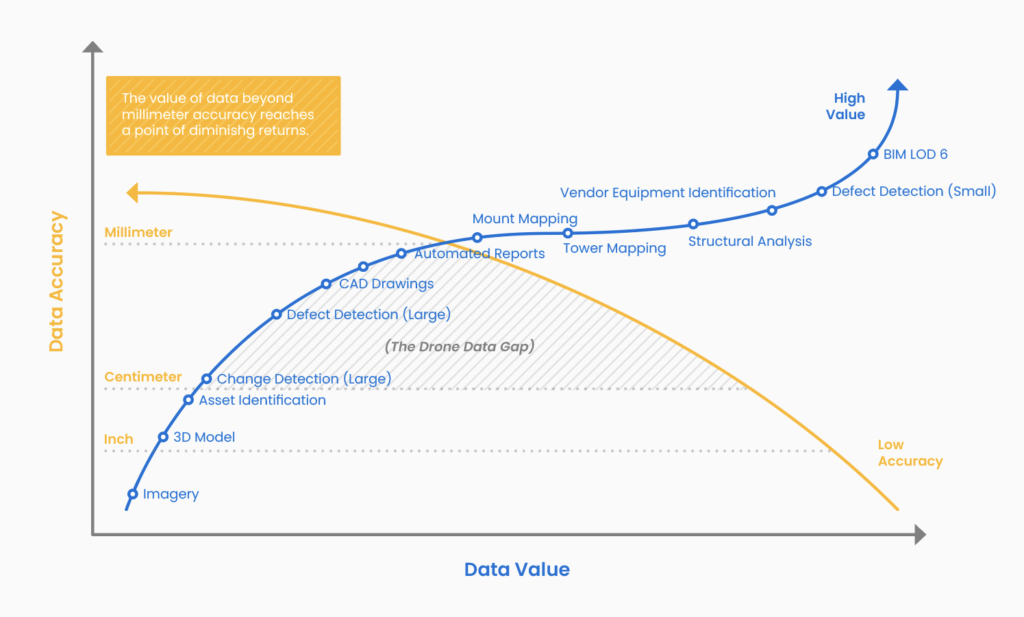
The data output is frequently unreliable, lacking both the level of detail and coverage required for most tower analysis. This in turn throttles the ability of artificial intelligence to perform a higher degree of automation and more sophisticated tower analysis. As a result, most analytics solutions today only address a narrow scope of field operations. We call this artificial limit on fidelity the “drone data gap” (figure 1). And considering that the cost to mobilize drones is largely labor and time – as owners, operators and engineers take a closer look the limited value these low-accuracy digital models provide, they’ve challenged drone companies to address this gap before scaling a drone program.
However, when drone sensors achieve millimeter accuracy, the potential of digital twins to augment and replace traditionally manual tasks grows exponentially.
Where digital models created from low fidelity centimeter-accurate sensor data fail to overhaul field and back office workflows, digital twins created using millimeter-accurate data unlock new capabilities that offset operational costs and enable organizations to become more data-driven and automated. By maximizing data fidelity and coverage, we’re exponentially increasing the ability for machine learning and artificial intelligence to augment and replace sophisticated manual tasks – herby unlocking unexplored workflows and previously unseen insights about tower assets (figure 2).
Achieving millimeter drone data accuracy on towers requires a different kind of sensor system. A system that meets engineering requirements and evolves the drone industry beyond its artificial constraints.
This led us down a path to build something that isn’t just better, but more importantly – something that is different than anything the industry has seen. Rather than develop software that is incrementally better, we set out to reinvent the sensor itself. And building on inimitable insider knowledge of the tower industry (gained by having founded and built one of the world’s largest and most successful tower companies), as well as decades of photogrammetry experience, we created the industry’s first and only aerial sensor capable of capturing 3D engineering-grade tower data.
For the first time, there is a unified drone platform that allows enterprises to capture and execute around engineering-grade tower digital twins. Not only does this automate the most basic of visual inspections – precision digital twins automate executional capacity at an engineering level, feeding insights upstream and across new business units. This enables tower companies to understand leasable inventory, continuously assess tower capacity in real-time, and effortlessly operate across teams, vendors and geography.
As the industry explores the potential of drones to help address and economics of rolling out 5G infrastructure at scale, millimeters are the difference between augmenting inspections and insight automation. Millimeters are the difference between photo-realistic 3d models and as-built digital twins. And millimeters are the difference between truck rolls and digital transformation.
For the tower industry – millimeters matter.


